London Borough of Bromley
| London Borough of Bromley | |||
|---|---|---|---|
| — London borough — | |||
|
|||
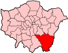
| Bromley shown within Greater London | |||
| Sovereign state | United Kingdom | ||
| Constituent country | England | ||
| Region | London | ||
| Ceremonial county | Greater London | ||
| Status | London borough | ||
| Admin HQ | Stockwell Close, Bromley | ||
| Incorporated | 1 April 1965 | ||
| Government | |||
| - Type | London borough council | ||
| - Body | Bromley London Borough Council | ||
| - Leadership | Leader (Cllr Stephen Carr) & Cabinet (Conservative) | ||
| - Mayor | Cllr George Taylor | ||
| - MPs | Jo Johnson Bob Stewart Bob Neill Jim Dowd |
||
| - London Assembly | James Cleverly AM for Bexley and Bromley | ||
| - EU Parliament | London | ||
| Area | |||
| - Total | 58 sq mi (150.15 km2) | ||
| Area rank | 188th (of 326) | ||
| Population (2008 est.) | |||
| - Total | 302,600 | ||
| - Rank | 24th (of 326) | ||
| - Density | 5,219.6/sq mi (2,015.3/km2) | ||
| - Ethnicity[1] | 83.1% White British 1.5% White Irish 4.2% Other White 0.8% White & Black Caribbean 0.3% White & Black African 0.7% White & Asian 0.5% Other Mixed 1.9% Indian 0.4% Pakistani 0.4% Bangladeshi 0.7% Other Asian 1.8% Black Caribbean 1.9% Black African 0.3% Other Black 0.7% Chinese 0.7% Other |
||
| Time zone | GMT (UTC0) | ||
| - Summer (DST) | BST (UTC+1) | ||
| Postcodes | {{{postcode_areas}}} | ||
| Police force | Metropolitan Police | ||
| Website | bromley.gov.uk | ||

The London Borough of Bromley (pronunciation) is a London borough of south east London, England and forms part of Outer London. The principal town in the borough is Bromley.
The Prime Meridian passes through Bromley.
Contents |
Geography
The borough is the largest in London by area and occupies 59 square miles (152.8 km2), of which the majority is green belt land. Most of the settlement is in the north and west of the borough, with an outlier at Biggin Hill in the far south. The borough shares borders with Lewisham, Greenwich and Bexley to the north, Southwark and Lambeth to the north west, Croydon to the west; and the counties of Surrey to the south and Kent to the south and east. Westerham Heights, the highest point in London at an altitude of 245 metres, is located on the southern boundary.
History
The borough was formed, as were all other London boroughs, on April 1, 1965 by the London Government Act 1963. It comprised the former area of the Municipal Borough of Bromley, the Municipal Borough of Beckenham, Penge Urban District, Orpington Urban District and the Chislehurst part of Chislehurst and Sidcup Urban District, which was transferred from Kent to Greater London.
In 1969, after a local campaign, the village of Knockholt was transferred back to Kent to become part of the Sevenoaks Rural District and later Sevenoaks District. Before 1965 it had been part of the Orpington Urban District.
The Borough
The borough is the largest in Greater London in terms of area at approximately 150 kmsq. As one of the outer London Boroughs it can be shown to be in two parts: urban and rural, the former to the north and very much part of the built-up area which is suburban London.
The principal parts of the northern section, from west to east, are Beckenham, which includes Eden Park and Elmers End; Bromley with Bickley, Bromley Park and Bromley Common, Park Langley, Plaistow, Shortlands, and Southborough; Chislehurst, with Elmstead and Sundridge. The built-up area around Orpington not only encompasses its direct outskirts of Chelsfield, Crofton, Derry Downs, Goddington, Kevingtown, and Petts Wood; it also includes the erstwhile separate settlements of Farnborough, Green Street Green, Pratts Bottom, St Mary Cray and St Paul's Cray. Other smaller suburban areas include Anerley and nearby Crystal Palace; and Penge. In addition, parts of Mottingham, Ruxley and Swanley lie within the Borough boundaries.
There are two main areas in the southern part of the Borough: Hayes and West Wickham. Biggin Hill, Downe and Keston with Leaves Green and Nash are separate, smaller, rural settlements. Local attractions include Down House (the home of Charles Darwin), Chislehurst Caves, Holwood House (the home of William Pitt the Younger), Crofton Roman Villa, and the site of The Crystal Palace.
Governance
Bromley consists of 22 wards made up of 60 council seats. These are currently represented by 53 Conservative, 4 Liberal Democrat and 3 Labour councillors.
Since the Borough’s creation, Bromley had always been under Conservative control until the local elections of 7 May 1998 when a Liberal Democrat/Labour coalition assumed power. Following a number of by-elections and a defection, the Conservatives regained control on 5 July 2001.
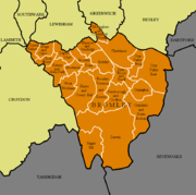
The 22 wards are shown on the accompanying map. Ward names often straddle the named settlements and suburban areas above: their boundaries are fixed, whereas the latter are not.
Demographics
| Population | ||
|---|---|---|
| Year | Pop. | %± |
| 1801 | 8,944 | — |
| 1811 | 10,186 | 13.9% |
| 1821 | 11,455 | 12.5% |
| 1831 | 13,302 | 16.1% |
| 1841 | 14,878 | 11.8% |
| 1851 | 17,192 | 15.6% |
| 1861 | 33,144 | 92.8% |
| 1871 | 49,095 | 48.1% |
| 1881 | 65,046 | 32.5% |
| 1891 | 84,729 | 30.3% |
| 1901 | 99,502 | 17.4% |
| 1911 | 116,851 | 17.4% |
| 1921 | 140,960 | 20.6% |
| 1931 | 170,073 | 20.7% |
| 1941 | 216,821 | 27.5% |
| 1951 | 276,438 | 27.5% |
| 1961 | 290,065 | 4.9% |
| 1971 | 304,414 | 4.9% |
| 1981 | 294,547 | −3.2% |
| 1991 | 294,723 | 0.1% |
| 2001 | 295,560 | 0.3% |
| Source: A Vision of Britain through time | ||
In 1801, the civil parishes that form the modern borough had a total population of 8,944. This rose slowly throughout the 19th century, as the district became built up; reaching 17,192 in the middle of the century. When the railways arrived the rate of population growth increased. The population peaked in the 1970s, when industry began to relocate from London.
In the 2001 Census, the borough had a population of 295,532 – of whom 141,785 were male, and 153,747 female. All major religions are represented, but of those stating a choice, 72.03% described themselves as Christian, and 16.34% as having no religion. Of the population, 43.47% were in full-time employment and 11.06% in part-time employment – compared to a London average of 42.64% and 8.62%, respectively. Residents were predominantly owner-occupiers, with 32.53% owning their house outright, and a further 42.73% owning with a mortgage. Only 1.42% were in local authority housing, with a further 12.74% renting from a housing association, or other registered social landlord.[2]
Education
Transport
Bromley is one of only five London Boroughs not to have at least one London Underground station within its boundaries.
Crime
Crime rates in Bromley are lower than most other London suburbs.[3]
| Offence | Locally | Nationally |
|---|---|---|
| Robbery | 3.01 | 1.85 |
| Theft of a motor vehicle | 5.20 | 4.04 |
| Theft from a motor vehicle | 10.99 | 9.59 |
| Sexual offences | 0.98 | 1.17 |
| Violence against a person | 18.38 | 19.97 |
| Burglary | 7.06 | 5.67 |
London Fire Brigade
London Fire Brigade has four fire stations within the London Borough of Bromley. The borough is the largest in the city; at approximately 150 kmsq. With just one pumping appliance, Orpington has one of the largest station grounds in London, measuring 46.7 kmsq. In 2006/2007, Orpington attended 1,308 incidents. There is also a high volume pump at the station. Beckenham, Bromley and Biggin Hill cover the rest of the borough with four pumping appliances and a hose layer.[4]
In 2006/2007 just under four thousand incidents were attended to in the borough. Noticeably, compared to 2005/2006 there was an 11% decrease in special service calls (road traffic collisions, chemical incidents, flooding etc).
London Fire Brigade - Bromley Profile
Twin towns
 Neuwied, Germany.
See also
- Bromley parks and open spaces
References
- ↑ Data Management and Analysis Group, Greater London Authority, Demography Update October 2007, (2007)
- ↑ Key Figures for 2001 Census: Census Area Statistics: Bromley accessed 25 February 2009
- ↑ "Bromley crime statistics". FindaProperty.com. 2005-06. http://www.findaproperty.com/crimefacts.aspx?edid=00&salerent=0&areaid=0307.
- ↑ http://www.london-fire.gov.uk/about_us/media/Bromley.pdf London Fire Brigade - Bromley Profile
External links
- Summary of formation of the Borough, including its constituent parts
- London Borough of Bromley council website
- London Borough of Bromley Museum
- Bromley mytime - local sports facilities
- Council for Voluntary Service for the London Borough of Bromley
- Directory of local community services
- http://www.bromley.gov.uk
- Images of Bromley
- Bromley Neighbourhood Watch Association website (BromleyNWA.org.uk)
|
||||||||||||||||||||
|
||||||||||||||